Group4
Member list
Japanese members
Dr. Hiromichi Fukui
Group leader
Chubu University
Professor
Dr. Satoru Sugita
Chubu University
Associate Professor
Dr. Ryosuke Shibasaki
University of Tokyo
Professor
Dr. Hiroyuki Miyazaki
University of Tokyo
Project Assistant Professor
Dr. Yuki Akiyama
Tokyo City University
Associate Professor
Dr. Manandhar Dinesh
University of Tokyo
Project Associate Professor
Thai members
Dr. Thanaruk Theeramunkong
Group leader
Thammasat University Professor
Dr. Apichon Witayangkurn
Asia Institute Technology
Dr. Teerayut Horanont
Thammasat University Assistant Professor
Dr. Nikorn Sutthisangiam
King Mongkut’s University of Technology North Bangkok Associate Professor
Dr. Kanokvate Tungpimolrut
NECTEC Deputy Director
Abstract
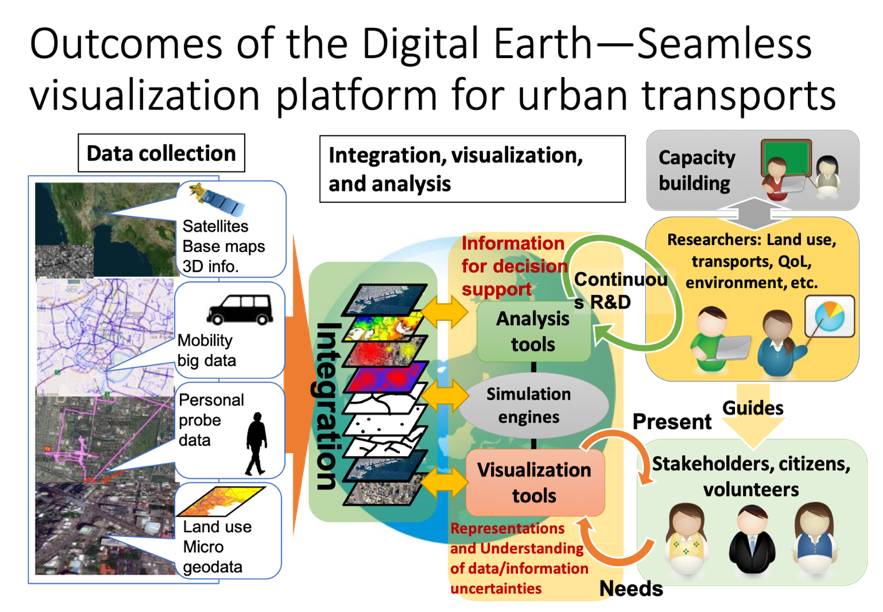
In Bangkok as a whole, we will build a system to accumulate spatio-temporal information such as land use and topography, which are the foundation of the city, road network and building information, which are the infrastructure, as well as various types of traffic probe information and micro-geodata, which are the information of people operating on the infrastructure. The system will consolidate data such as the results of studies conducted by each group to achieve seamless visualization.
Research contents
1.Study on the framework for integrated visualization of land use and transportation information using Digital Earth
We will examine the availability and routes of basic information necessary to carry out this research project by contacting the relevant organizations. We will also examine how to perform higher-order processing of the data, how to quantify and visualize the required amount, and how to create a platform for integrating and sharing the data, and compile this into a framework for integrated visualization.
2.Development and maintenance of micro-geodata on land use
We will establish a methodology for estimating and creating micro-geodata on the distribution of people, households, stores, and businesses in each building unit by integrating statistical data, field survey data, map information, etc., and downscaling the data, and apply it to the Sukhumvit district and other areas to develop and visualize micro-geodata.
3.Development and acquisition of mobile big data analysis system
We will develop and visualize a system for organizing, structuring, storing, and analyzing cab probe data held by cab companies in Thailand. In addition, in cooperation with the National Broadcasting and Telecommunication Commission (NBTC), we will use cell phone call records (CDR data) of one million people, which are linked to base station location information, to measure people’s mobility more accurately and continuously. and continuous measurement.
4.Development of a personal probe system for spatio-temporal QOL measurement and evaluation (collection of behavioral history, behavioral schedule, etc. through the development of a smartphone application for individuals)
As basic information for measuring and evaluating the spatio-temporal QOL of individual residents, we will develop an application for each individual’s smartphone to collect behavioral history, activity schedule, etc. By linking with Google calendar, etc., we will minimize the need for inputting information and enable long-term continuous monitoring.
5.Integrated visualization using digital earth system
As a basis for supporting decision-making and consensus-building in the “Smart Transportation Integrated Strategy Method”, we will visualize and share the resultant data of research items 1 to 3 and the above information on Digital Earth in a multi-scale and seamless manner.